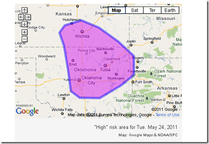
Above is the latest graphical representation of where significant weather is anticipated this afternoon and evening.
NOAA's Storm Prediction Center typically issues a high risk for severe t-storms only when a major severe weather outbreak is anticipated. This often includes a concentration of strong tornadoes.
TOR:CON values for Tuesday include:
- KS southeast – 6
- MO – 5
- OK north-central – 8
- OK northeast - 5 to 6
TOR:CON Value Descriptions
-
8: High probability of a tornado
-
6: Moderate possibility of a tornado
-
4: Low chance of a tornado nearby, but hail and/or strong wind gusts possible


No comments:
Post a Comment
All comments are moderated before being posted. Postings are at the sole discretion of the blog moderator. Anonymous postings are no longer allowed. I encourage your comments, but put you name on the bottom line!